
Obviously as a crime data site handling payment, you have to be an example. It was however recently pointed out to us that we were not. Basically, images uploaded via wordpress must have an https link otherwise the whole page is deemed to be insecure. This has now been fixed. But you will see that all of our pages are now https and show up as having the padlock sign in the url display of your browser which is more than having an SSL certificate (which we do – GoDaddy).
For your protection – UKCrimeStats is a secure https site . . .
November 21st, 2018
Crime now updated to September 2018 – but . . .
November 9th, 2018You should know that as with every month, there are a few Forces that have either not updated on time or are incomplete. These are;
Metropolitan Police Force – no September data at all
Cheshire Constabulary – no ASB incidents for September (or indeed since February – pretty unlikely)
Bedfordshire Police – missing August and July
Cambridgshire Constabulary – still missing May, June, July, August
Thames Valley Police – have only reported ASB incidents but no crimes at all for September
We will keep going back and checking for updates every month. However the Home Office really needs to up their game in getting Police Forces to report in time – which they always used to.

Now updating crime to September 2018
November 8th, 2018The leading crime and postcode data research and analysis platform
Updated civil parishes for crime, property transactions and energy consumption . . .
November 7th, 2018Boundaries do change, much more frequently than those ordained by the Boundary Commission for constitutuencies for General Elections. We have deleted about 10 that no longer exist and added about 15 new ones like Axminster and Kilmington in Devon.
Ever wondered which Civil Parish in the whole country had the highest electricity consumption in 2015?
The answer is Sutton Coldfield – just to the North of Birmingham where there is plenty of industry. With a login, you can see and contrast electricity and gas consumption across all 11,057 Civil Parishes and indeed any other shape – as well as for crime and property transactions. You can subscribe here from £2.99 a month.

New feature – Static heatmap for a fixed period of time
November 2nd, 2018A special thanks to one of our subscribers who suggested it. For some time, we have show how crime moves over a selected period of months around a specified radius around a postcode centroid – anywhere in England, Wales or Northern Ireland covering some 1.6 million postcodes and 3, 2, 1, 0.5 and 025 miles radiuses. Then somebody pointed out, why don’t you just show a heatmap for a range of months as a static image?
So we did it.
Here is a static heatmap image of 1 mile radius around the postcode for 10 Downing Street – just in case you happen to live or work there . . .
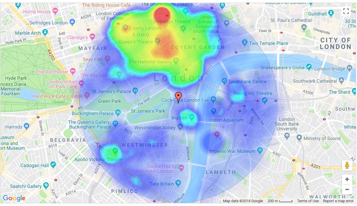 As you’ll see, most of it is concentrated in the Soho area to the North, there’s a spot around Big Ben, which will be Westminster Tube Station. Then there’s a bit around the South Bank and Victoria Station. 10 Downing Street though looks nice and safe, as you might expect.
By the way, we have to make this a subscriber only feature because it’s quite server intensive. With a login, you can run a static or monthy by month heatmap from this link here http://ukcrimestats.com/MembersArea/Heatmap/.
